Learn about the history of Cancun, the place with the largest real estate investment in the Mexican Caribbean.
Five decades ago, Cancun was a desert island and very few people knew it existed.
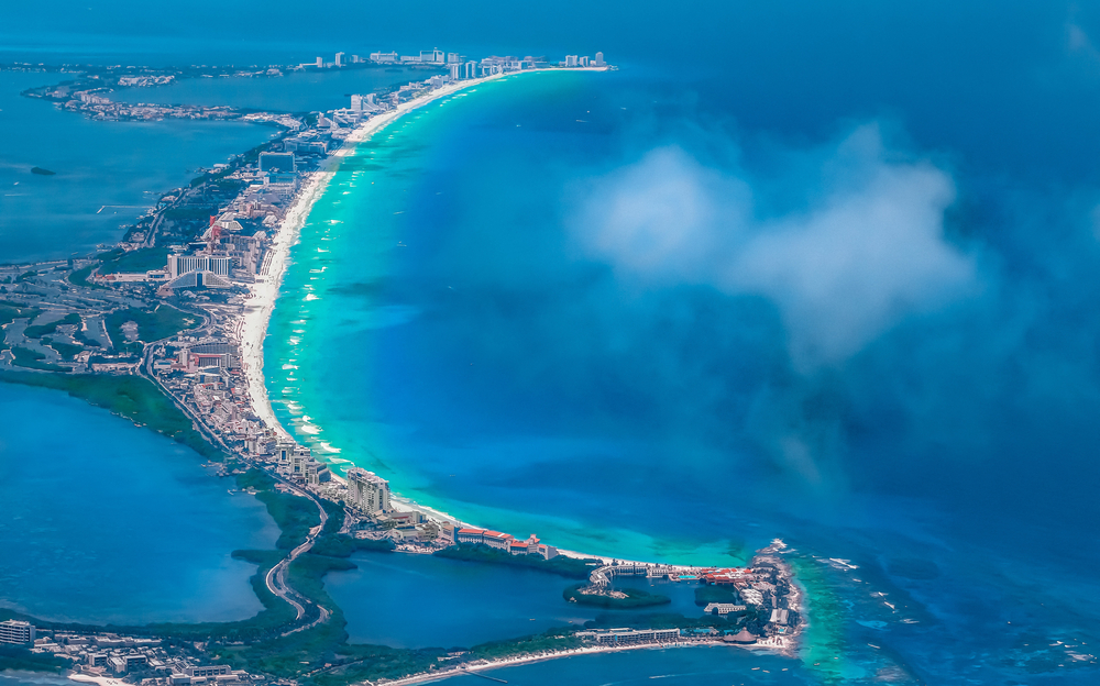
Located in a virgin region of the Caribbean, it consisted of a series of sand dunes in the shape of a number “seven”, some of which were just under 20 meters wide, separated from the mainland by two narrow channels that connected with a large lagoon system.
The Cancun coastline was made up of swamps, mangroves, virgin jungle, and unexplored beaches. Even in various geographical maps it could be found as “Kankun” (a single word written with the two “k”), which means “pot of snakes” or “nest of snakes” in the Mayan language.
However, in the early documents of Infratur (a government agency existing before Fonatur’s creation), it is written as two words, “Kan Kun”, and occasionally, “Can Cún” (in its Spanish form). The current name “Cancun” is a natural phonetic development that facilitates pronunciation … or perhaps it developed by chance.
The master plan:
The Cancun Project was officially approved in 1969, but did not begin until January 1970, when the first Infratur technicians arrived. The initial objectives of the project were to open a road from Puerto Juárez to the island, design a Master Development Plan and build a provisional airstrip (located in the area designated for the development of the city, on the site of the current Kabah Avenue ). in front of the ecological park).
The basic master plan required three elements:
- Build a tourist area without permanent residential areas, such as a tourist corridor (given the characteristics of the land itself), with hotel facilities, shopping centers, golf courses and marinas.
- Build a residential area for permanent residents. In other words, a comprehensive city, in the northern part of the land reserve, with residential and commercial areas, roads, public buildings, schools, hospitals, and markets.
- Build an international airport on one side of the Cancun-Tulum highway (under construction at that time), on the southern mainland of the island.
The development of the Hotel Zone was, in turn, divided into three phases. The first comprised the area from Bahía de Mujeres to Punta Cancún and the coast to the inner limit of the Bojorquez lagoon; the second phase extended from the Bojorquez lagoon to Punta Nizuc, and the third from the south of Punta Nizuc, to the limits of the territorial reserve.
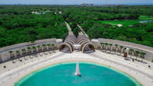
The design and segmentation of the hotel zone followed the concept of “superblocks” (subdivisions), architecturally known as the “broken plate diagram”: huge city blocks, separated by large avenues. The first segment of the urban area of Cancun was concentrated in what would become the main street of the city, Tulum Avenue. The City Hall was built on the largest lot in this area.
The first infrastructure projects for potable water (sump of 16 wells, at a distance of 30 kilometers / 18.6 miles), sewerage (excavate more than 100 kilometers / 62 miles of ditches for sewers connected to a treatment plant) and electricity (bring power lines from Tizimin, Yucatán, 150 kilometers / 93 miles away) cannot even compare to the scope and difficulty of the engineering projects required to create the Hotel Zone.
The equivalent of 240 hectares / 593 acres of topsoil was brought in by trucks: 100 (247 acres) for the golf course, 60 (148 acres) for Lot 18 A, and 60 for the area surrounding the El Rey ruins and they occupy more than 80 hectares / 198 acres (65 ha / 161 acres to expand the island and 15 ha / 37 acres for the airport road). Some 372,000 m3 (13,137,055 ft3) of mangrove systems were dredged to form the Siegfried and Nichupté canals to improve water exchange between the sea and the lagoons.
The first hotels opened in 1974 (Playa Blanca, Bojorquez and Cancún Caribe); the international airport was inaugurated with 2,600 meters of runway and operational capacity for wide-cabin airplanes; The government agencies of Infratur and Foqatur merged to form the National Foundation for the Promotion of Tourism (Fonatur).
The same year, Quintana Roo was granted statehood and the Cancun project (under the Isla Mujeres district government) became part of the Benito Juárez district.
From 1989 to date, Cancun has been the most dynamic city in the country. It contributes a large percentage of Mexico’s tourism-related income and accounts for much of Quintana Roo’s gross domestic product. There are currently more than 500,000 inhabitants in the urban area. Cancun has become the largest tourist center in the country and is the most prosperous city on the Yucatan Peninsula. It is also the main destination in the Caribbean, surpassing even the Bahamas and Puerto Rico.
The future is promising. Puerto Cancun, a huge luxury marina with low-impact hotels, is projected for development north of the hotel zone. To the southwest, towards the airport, the construction of more hotels, golf courses and a modern hospital is planned. In addition, the development of large tourist centers is contemplated for the 131-kilometer / 81-mile Cancun-Tulum tourist corridor.
Source: https://www.caribemexicano.travel/